Introduction to TIGER Radars
In developing the Tasman International Geopspace Environment Radar (TIGER) the aim has been to extend the SuperDARN network in the Southern Hemisphere, but with the important difference of extending coverage to the sub-auroral region.
This provides opportunity to observe new phenomena and to improve the coverage of auroral phenomena during magnetic storms when the aurora expands equator-ward off the footprints of the other radars in the SuperDARN network.
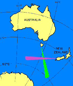
The TIGER footprints cover the lower latitude portion of the auroral oval and the ionospheric trough. The Tasmanian component, located on Bruny Island, began operation in December 1999, the New Zealand radar, located near Invercargill began operation in November 2004 and the Adelaide Radar (a digital version) located in the suburb of Buckland Park became operational in 2012.
Due to the radars excellent geophysical location, gives TIGER unique opportunities to study Geospace processes such as the Aurora Australis and related phenomena occurring in the ionosphere (100 to 300km) above the earth.
Since the radars are much closer to the south magnetic pole than the south geographic pole, this makes it an ideal location from which to monitor the interaction of the Solar Wind with the Earth's magnetic field. Its more equatorward location relative to the other Antarctic radars also allows it to better monitor events that move equatorwards during magnetic storms and out of the view of the Antarctic based radars.
The TIGER radars are directly across the magnetic pole from the British Antarctic Survey's SuperDARN radar at Halley, Antarctica. The TIGER - BAS alignment forms a unique radar pair providing opportunity for important simultaneous measurements of the aurora in the noon and midnight sectors.
The TIGER Tasmanian and New Zealand radars are based on the existing third generation HF radar constructed by the University of Leicester. The ionospheric physics group at Leicester remotely operates two of these radars in Finland and Iceland. Many other groups around the world use Leicester built radars. The Adelaide radar which is digital was designed and built at La Trobe University and won the 2014 Engineers Australia National Award for Development and Innovation.
This short video clip, courtesy of NASA shows and explains visually how the solar wind affects our planet. magneticfield_mpeg.mpg(6.53MB)
The following videos give a better insight of radars field of view Field of View(29.6MB) and Field of Power(42.8MB)
The study of Geopspace is important in its own right and for the development of improvements in Space weather prediction. The Geospace environment is a vast region at the outermost boundary of the terrestrial biosphere, extending from 60km above the Earth to millions of kilometres out in space. It encompasses the region where the solar wind interacts with the Earth's magnetic field, coupling energy into the magnetosphere and ultimately into the ionosphere and neutral atmosphere.
TIGER's specific mission is to take remote measurements of the ionosphere over the Southern Ocean and Antarctica to study these solar wind-magnetosphere-ionosphere interactions and provide information for space weather predictions that will enhance civilisation's capacity in the:
- - management of communications, surveillance, positioning and navigation systems
- - management of, and communication with, earth-observing satellite systems
- - management of long conductors (pipelines and power-lines)