J.A.E Stephenson and A.D.M. Walker
Space Physics Research Group, University of Natal, Durban 4041, South Africa
The SHARE radar was operating in a mode such that one of the radar's sixteen beams, beam number 5, was monitored every 20 s. This time resolution allowed spectra from Fourier analysis of the beam 5 velocity data to extend to 25 mHz. Inspection of RTI plots of beam 5 velocity data revealed that readings were concentrated in the geomagnetic band 65-70oS. Software was written to extract all beam 5 velocity data in this geomagnetic band from the appropriate FIT files for the six hour data interval. The data were then divided into five narrower latitude strips: 65-66o, 66-67o, 67-68o, 68-69o and 69-70o. This involved some range gate averaging so that one velocity value for each latitude strip every 20 s was achieved. These data are plotted in Figure 3 , with the most poleward latitude strip at the top and the 65-66o strip at the bottom. These plots show the considerable velocity variations present in the data. In particular, between 01 and 02 UT when beam 5 velocity values were very large, well in excess of 1 kms-1. This special period will be examined in more detail later.
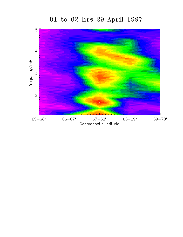
Each latitudinal data set was then divided into six parts of one hour duration, each one starting on the hour. A FFT was performed, after the DC was removed and a Hanning window applied, on each one degree strip, for each hour. The results of the FFTs for each hour are depicted by the six colours plots of Figure 4. The first plot is the spectrum for the first hour interval 00 to 01 UT with each successive hour below, ending at 05 to 06 UT. In each of the six colour plots, the FFTs for each latitude strip are laid vertically side by side to form a type of spatial spectrogram. Peak magnitudes are colour coded such that greens, yellows and reds represent the highest absolute amplitudes. Frequencies from 1 to 5 mHz are shown, corresponding to Pc5 geomagnetic pulsations. Inspection of this six plot time series indicates that Pc5 pulsations tend to be confined to narrow zonal bands. In addition, they tend to be present at higher latitudes at the beginning of the data set, move to lower latitudes in the middle, and then migrate polewards towards the end.
The spectra for frequencies in the range 5 to 25 mHz show a somewhat different result as the Pc4 pulsations are confined to the high latitude strips throughout the six hour data set. The upper plot in Figure 5 is the Pc4 spectrum (top colour plot) for the time interval 01 to 02 UT which, as mentioned previously, is the time during which velocity variations are largest. In addition, the spectrum of the declination (in degrees) of the Earth's magnetic field, as recorded by AGO81 situated under the 68-69o geomagnetic strip of beam 5, is given below. Comparing the two plots one can see that the peaks in both spectra are closely matched for this time interval.
A geomagnetic field model was used to map the region of occurrence of the pulsations at ground level to the equatorial plane. The Tsyganenko T96_01 model takes into account contributions from both external and internal sources. Results of the mapping into the magnetotail of this nighttime data set are show in Figures 6 and 7 for Pc5 (1 to 5 mHz) and Pc4 (5 to 25 mHz) pulsations respectively. Each latitude strip maps out to a shell in the equatorial plane. The shells are bracketed and marked with the hour intervals that the pulsations appeared on them. Figure 6 illustrates that Pc5 pulsations tend to map out to a range of distances between 10 and 35 RE throughout the data set. A result consistent with cavity mode theory. On the other hand, the Pc4 pulsations, as shown in Figure 7, are not constrained within a narrow range, suggesting that the region of activity has convected. In this case the pulsations tend to originate around the region 12 to 25 RE at the start of the data set, they then extend to distances over 50 RE by 02 UT, and by 04 UT have returned closer in.
These results are now being investigated
further.


Figure 2: Solar wind velocity components, ion concentrations
and pressure measured by the WIND satellite
Return to text


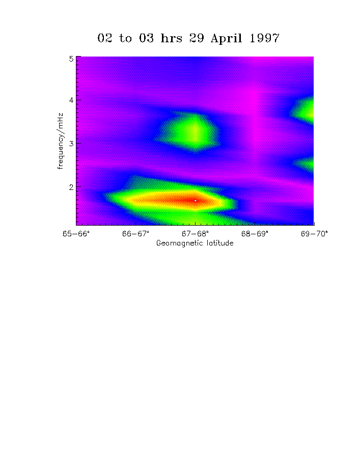
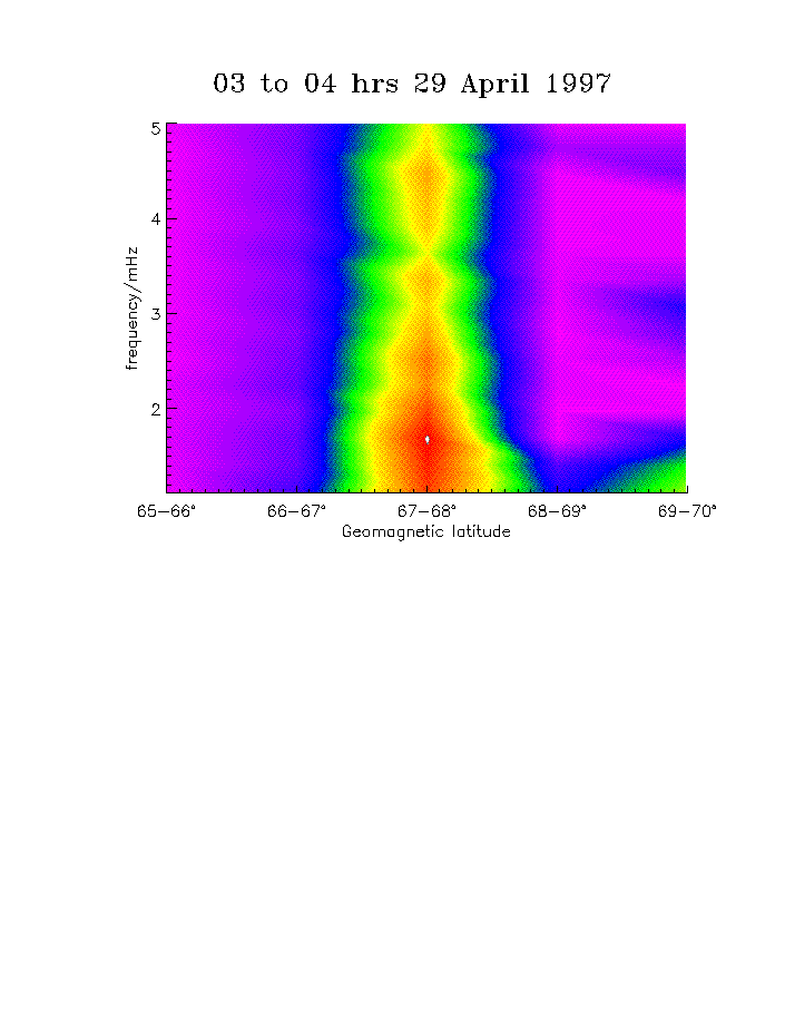
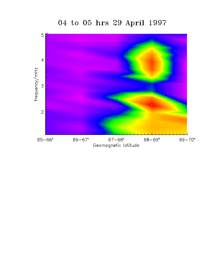
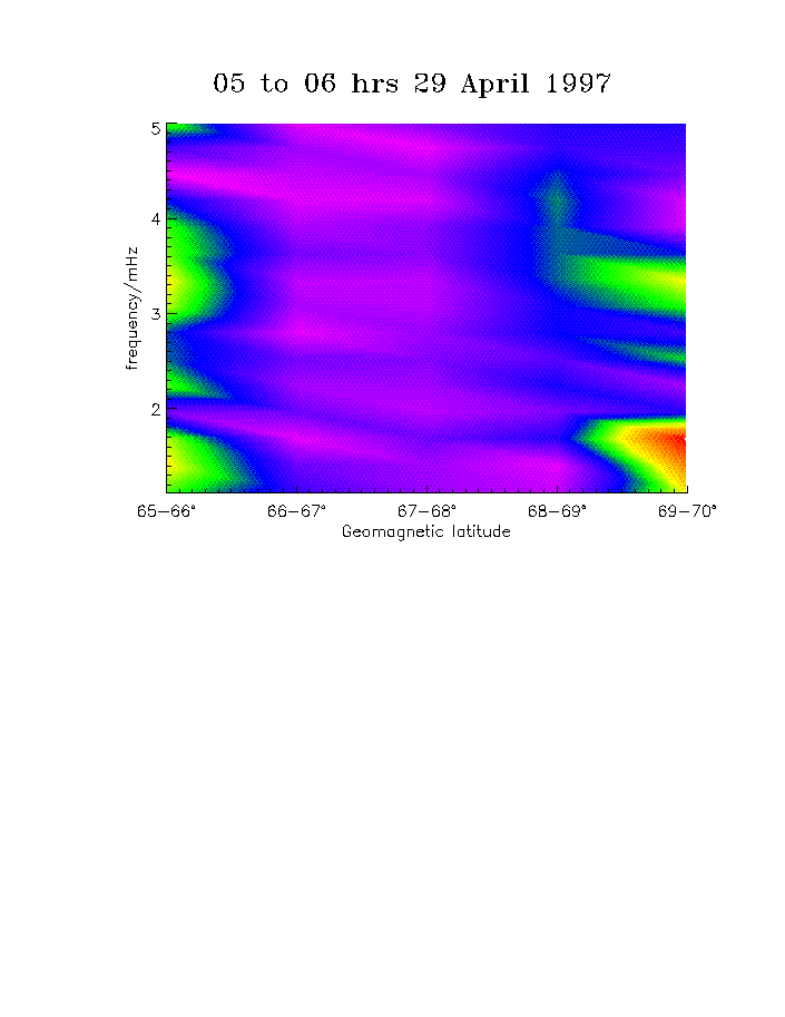
Figure 4: Hourly colour plots of spectra from FFTs on
latitudinal strips of HF radar doppler velocity. Pc3 pulsation frequencies
only.
Return to text
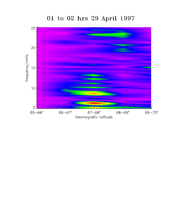
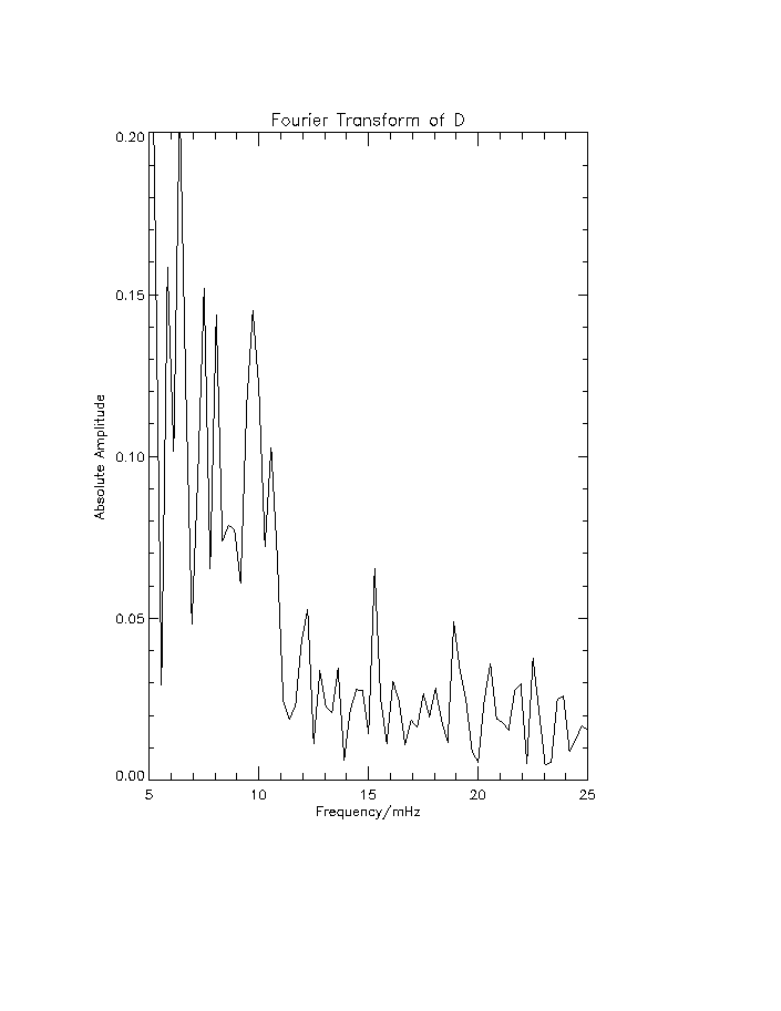
Figure 5: Two spectra for the time interval 01 to 02
UT. The top plot is a colour spectrogram, similar to those in Figure 4,
but for shorter period Pc4 pulsations. Lower plot is the resulting spectrum
from an FFT on the declination (in degrees) of the geomagnetic field measured
by AGO81.
Return to text

Figure 6: A plot of the mapping of ground level coordinates
of Pc5 pulsations observed in the HF radar beam 5 velocity data to the
geomagnetic equatorial plane using the Tsyganenko T96_01 model.
Return to text
